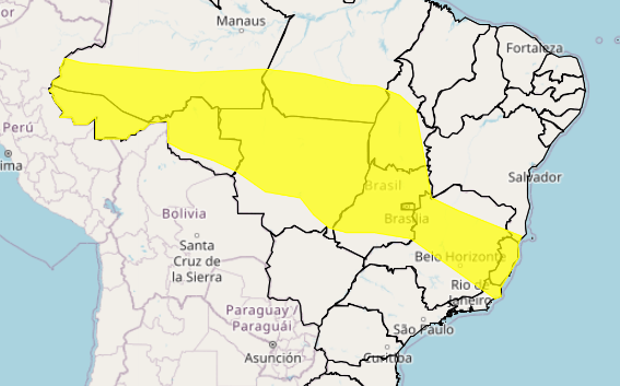
Between March 24th and 31st, the numerical model Cosmo, from the National Institute of Meteorology (Inmet), indicates rain concentrated in a large part of the North Region, west and north of the Northeast Region, north of the Central-West Region, east of the Southeast Region and part of the States of Rio Grande do Sul and Santa Catarina.
In these areas, accumulations may exceed 80 mm (red tones) during the week. In the center-east of Bahia, Alagoas, Sergipe, Pernambuco, north of Minas Gerais, as well as the east of Mato Grosso do Sul, São Paulo and Paraná, the tendency is for rainfall to occur with accumulations below 20 mm (blue tones).
In the North Region, the highest rainfall accumulations will be concentrated in western Amazonas, Pará, Amapá, as well as eastern Tocantins and Rondônia, with accumulations that may exceed 60 mm (orange and red tones). Lower volumes are forecast for Roraima, northeastern Amazonas and northwestern Pará, with values below 40 mm.
In the Northeast Region, areas of instability due to the presence of the Intertropical Convergence Zone (ITCZ) will still favor precipitation in the north of Maranhão and Piauí, and on the coast of Ceará, where rainfall volumes above 60 mm (orange and red tones) are expected, mainly between March 28 and 30. In the eastern strip of the region, which goes from Rio Grande do Norte to Pernambuco, accumulations of less than 20 mm are expected. In areas of the central part of Bahia and the interior of the states of Pernambuco, Alagoas and Sergipe, there may be no rainfall.
In the Central-West Region, the forecast is for irregular rainfall and areas of instability more localized over the northwest of Mato Grosso, north of Goiás, and the Federal District, with accumulations that may exceed 50 mm. At the beginning of the week, areas of the south and west of Mato Grosso do Sul are expected to have rainfall volumes that may reach 50 mm in twenty-four hours, with winds of up to 60 km/h and the possibility of hail. From March 29th onwards, the trend is for lower rainfall accumulations and less than 20 mm over the east of Mato Grosso do Sul.
In the Southeast Region, rainfall of over 60 mm is expected on the border between Minas Gerais, Rio de Janeiro and Espírito Santo during the week. In the north of Minas Gerais, the weather is expected to be stable and some areas in the center-south of São Paulo may register volumes of less than 10 mm.
In the western part of the South Region, the week begins with storms and rainfall volumes of up to 50 mm in twenty-four hours, winds of up to 60 km/h and the possibility of hail. However, the weather should become more stable from the end of the week.


