During this week, a new cold front is expected to advance across the country. The configuration of the system should contribute to the strong advance of a polar air mass. This is because, this Monday (17) we still have the action of a front that formed over the weekend, with its low pressure core between the coast of the South and Southeast regions of the country.
The tendency is for a new cyclone – a low pressure system – to form in the ocean at the end of next Wednesday (19), right behind the cold front that is currently acting. The winds associated with the cyclone, blowing from south to north, should significantly boost the polar air mass to areas in central Brazil.
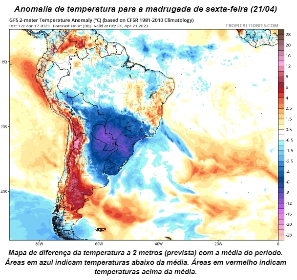
By Friday (21) the cold weather is expected to reach the south of Goiás and the southern half of Minas Gerais. Temperatures in the early hours of Friday morning are expected to be close to or below 13°C in the capital of Minas Gerais and in the southwest of Goiás. On average, projections are expected to be below 5°C between the north of Rio Grande do Sul and the south-central part of Paraná.
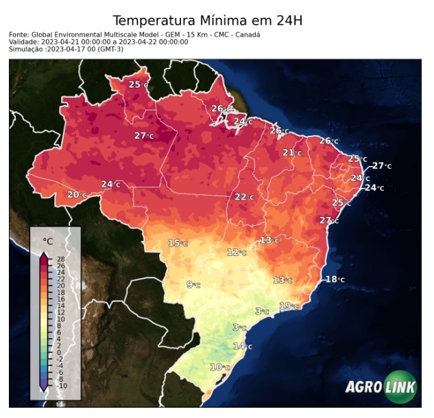
Projection of strong cold by the Canadian model.
Although the forecast is for a medium-term period, some projections, such as that of the Canadian center, indicate a more intense cold for the early hours of Friday. The forecast shows temperatures of up to 3°C in Curitiba and the capital of São Paulo. At the same time, the minimum temperatures at dawn on Friday should be close to 15°C in Cuiabá and 13°C in the Federal District. In coastal regions, the cold will not be as intense as in the interior or mountainous areas, which is why temperatures vary between 10 and 14°C in Porto Alegre and Florianópolis.
However, the projection for this center specifically indicates temperatures of up to 1°C in the highest points of the Serra Gaúcha and Serra Catarinense, as well as in the mountainous areas of southern Minas Gerais. Furthermore, the possibility of light frosts in eastern São Paulo and in the Serra Mineiras cannot be ruled out.
Condition for frost formation
After the passage of the cold front (rain system), the establishment of the polar air mass comes together with a high-pressure region. High-pressure areas are associated with drier weather, as the air moves from top to bottom, preventing the formation of heavy clouds. And the combination of clear skies, calm winds and strong cold are conducive to the formation of frost.
On cold, clear nights, the process of heat loss from the ground to the atmosphere becomes faster, so the layer of air near the surface can become colder than the air above it, creating a temperature inversion. When moisture is present, this layer of cold air can form ice crystals that accumulate on exposed surfaces such as grass, cars, and roofs.
The forecast for the formation of the phenomenon takes into account low air temperatures, high relative humidity, few or no clouds in the sky and the loss of heat from the ground. And they are more common to form in regions of higher altitude, or in low-lying areas.
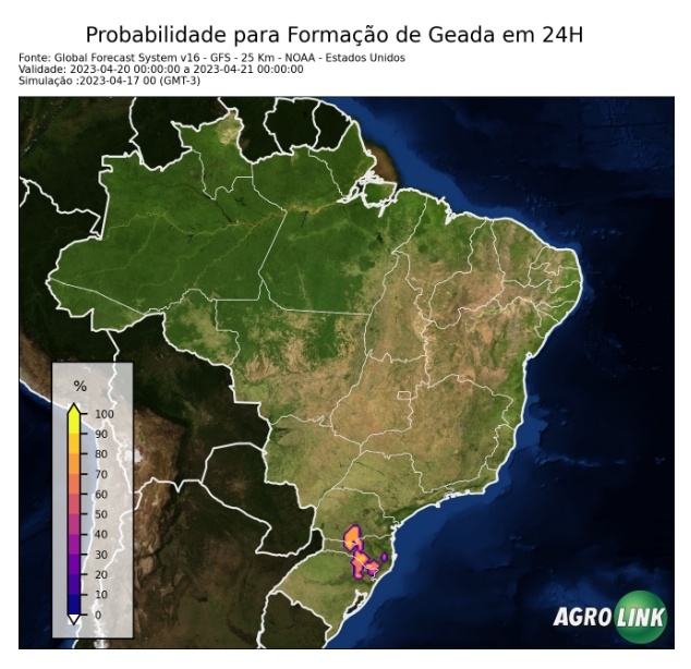
Frost may form during the night of Thursday (20), mainly between the north of Rio Grande do Sul and the south of Paraná.
Bulletin prepared by the Agrotempo team*


