EN
 PT_BR


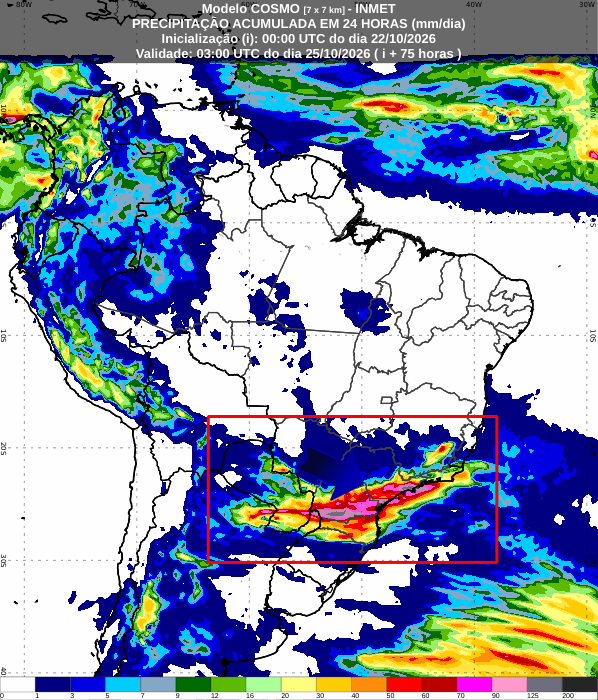
The formation of an extratropical cyclone between the coast of Rio Grande do Sul and Uruguay, associated with the passage of a cold front, should intensify rainfall in the Central-South of Brazil during the weekend. The forecast indicates a risk of storms, hail, wind gusts and high volumes of rain, mainly in Paraná and Santa Catarina this Saturday (24). On Sunday (25), the instabilities advance to São Paulo, Mato Grosso do Sul and southern Minas Gerais.
According to meteorologist Denis William Garcia of Meteored, the low-pressure system and the associated cold front favor the formation of storm clouds and the maintenance of unstable areas over the region.
The meteorologist points out that, although the cyclone is moving towards the ocean, the cold front will continue advancing across the continent, bringing rain to other areas of the country. The trend is for the system to cross the South-Central region over the next few days, with varying levels of intensity.
Saturday will bring a risk of storms and hail to the South.
Saturday is expected to bring the most concerning weather conditions to Paraná, Santa Catarina, and northern Rio Grande do Sul. Heavy rain is forecast for the morning, with the possibility of hail, particularly in northern Rio Grande do Sul, central-western Santa Catarina, and central-southeastern and southwestern Paraná.
Throughout the day, unstable weather patterns are expected to persist, bringing risks of storms, strong wind gusts, and significant rainfall accumulation in short periods. According to Denis, these conditions could cause flooding, overflowing rivers, and power outages.
"We need to be on alert for this region on Saturday, especially in Paraná and also in Santa Catarina, and during the dawn here in areas of northern Rio Grande do Sul," warns the meteorologist.
In Rio Grande do Sul, the rain may also intensify in parts of the west and northwest of the state. However, the trend is for the most intense instability to be concentrated in Santa Catarina and Paraná.
Sunday: Heavy rain moves towards São Paulo and Mato Grosso do Sul
On Sunday (25), the cold front advances and changes the distribution of rainfall. While Rio Grande do Sul and part of Santa Catarina may experience a temporary reduction in precipitation, instability gains strength in Paraná, Mato Grosso do Sul and São Paulo.
The forecast indicates heavy downpours and the possibility of storms in the interior of São Paulo state, southern Minas Gerais, and the Campo Grande region, as well as areas near the border between Mato Grosso do Sul and São Paulo. Rain is also expected to reach other parts of Minas Gerais, Rio de Janeiro, and Espírito Santo, although with uneven distribution.
Denis points out that the afternoon period requires special attention, when the increase in temperatures, combined with the moisture available in the atmosphere, favors the formation of new areas of instability.
"During the afternoon, as temperatures rise and we have moisture present in that region, we have these more scattered rains over the south-central part of the country," he explains.
In the eastern part of the Southern Region, the cyclone's circulation can also transport moisture from the ocean to the continent, contributing to the formation of new rain clouds.
The North and Northeast regions will experience more localized rainfall.
While the South-Central region has the highest risk of severe storms, much of the North and Northeast should experience more stable weather. In the Northeast, rainfall will be concentrated along the coast, with isolated showers in some inland areas.
In the Northern Region, the forecast indicates localized rain in Amazonas, including the possibility of showers in areas of Manaus. Denis points out that satellite images show an area of instability advancing towards the Amazonian capital, although the models do not indicate significant rainfall volumes.
Rainfall may bring some temporary relief to the population affected by the smoke from the wildfires, but there is no guarantee that the rain will reach the entire city or be sufficient to significantly improve air quality.
Cold fronts also cause a drop in temperatures.
In addition to the rain, the cold front is expected to cause a drop in temperatures in Rio Grande do Sul and southern Santa Catarina starting on Saturday. On Sunday, the weather will be milder in parts of the Southern Region, while instability continues to move through the South-Central region.
The meteorologist emphasizes that the situation requires monitoring, especially in areas with forecasts of heavy rain and the possibility of hail. The distribution of storms may vary from one location to another, and the largest volumes tend to occur irregularly.